
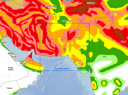
Ground acceleration map of Pakistan earthquake. Map courtesy of the US Geological Society
A powerful 7.7 magnitude earthquake struck south-west Pakistan this morning, killing at least 30 people according to local reports.
The earthquake struck at 16:29 local time (11:29 GMT) near Awaran in the Balochistan region of Pakistan and could be felt across the region including in Delhi, the capital of neighbouring India. The area is sparsely populated, and some distance from any major cities, but the earthquake cause around 30% of the houses in the Awaran district to collapse according to a spokesperson from the Balochistan assembly.
According to Pakistan’s Geo News, the earthquake caused the formation of a new island off the coast of Gwadar. The new island, which formed around 100m of the coast, is around 30m across and 10m high.


